America will get ‘no rest’ from the diabolical weather as a ‘major pattern ‘shift’ drives a 20-state month-long storm assault.
Dangerously volatile atmospheric conditions fuelled by tropical heat will unleash a barrage of thunderstorms lasting into mid-July.
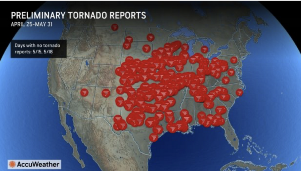
It comes as the seasonal tornado record topples after around 1,100 twisters struck during spring.
The tally could rise still as a high-pressure ‘heat dome’ sends temperatures soaring during summer.
America to get ‘no rest’ as thunderstorms to last until mid-July
Accuweather
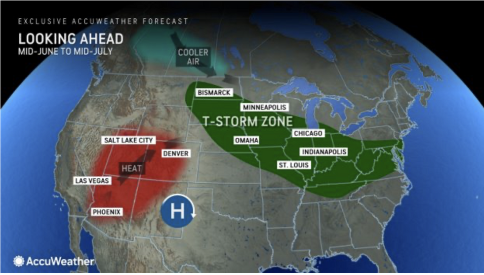
AccuWeather chief meteorologist Jon Porter said: “A major pattern shift will bring the threat of severe thunderstorms with widespread wind damage to 20 states over the coming weeks.
“There will not be any rest for people across the Midwest that have been dealing with rounds of tornadoes.
“There are more concerns around damaging winds, and while we’re not saying they will occur everywhere, it is in these areas that we want people to be especially weather aware over the next couple of weeks.”
An area of strengthening high pressure over southern states, driving up temperatures, will boost the surge, he warned.
LATEST DEVELOPMENTS:
He said: “An area of high-pressure is forecast to amplify over parts of the Southern United States, and the severe-weather risk is evolving toward fast-moving thunderstorm clusters, notorious for producing destructive winds over a large area.”
A corridor from the Dakotas to the Great Lakes will be at ‘heightened risk’ of thunderstorms and ‘destructive’ winds into mid-July, AccuWeather Said.
More than 1,000 tornado reports so far this year will land 2024 as the ‘most severe active weather year’ since 2011.
Mr Porter said: “The tally of preliminary tornado reports across America has topped the 1,100 mark, well above the historical average of 792 tornadoes for this time of year.
“Tornadoes have been reported across 38 states this year.”
Tornado hits already breaking records
Accuweather
As a giant heat dome spreads across America, the meeting point of cool and hot air will become a spawning point for further tornadoes.
The twister threat will move further north than the typical ‘tornado alley’ as high pressure swamps the country.
Jim Dale, US weather correspondent and meteorologist for British Weather Services, said: “The tornado season will move further north as the cooler air out of the Rockies and Canada hits the heat.
“The heat dome will be over the west and the south of the country, and on the periphery, there will be some major thunderstorm action.
“This heat is going to build through the week and through the rest of the month, and so will the risk of severe weather.”
Severe weather since the start of the month, after weeks of storms through spring, has already left a trail of destruction and led to one death.
Weather Channel reporter Tim Harris said: “A sudden tornado in Michigan killed a 2-year-old boy and critically injured his mother.
“In Muskingum County, east of Columbus, reports from a local emergency manager indicated damage to buildings and infrastructure in Frazeysburg.
“Eight people sustained minor injuries.”
America’s National Weather Service (NOAA) has issued further warnings for flash flooding across western states, and heat in the south.
A spokesman said: “Excessive Heat will build into central California over the next several days while thunderstorms will be possible from the High Plains to the coast of the Carolinas.
“Areas of heavy rainfall are possible in the Plains and mid-Mississippi River Valley.”