America’s storm assault is about to get a turbo-charge with explosive spring weather conditions threatening up to 1,500 tornadoes.
Blasts of tropical warmth from the south colliding with Arctic winds to the north will fuel a surge of raging twisters.
The volatile climate will throw into the mix the added risk of ‘derechos’ – ferocious ‘inland hurricanes’.
And in a swerve from the norm, superpowered tornadoes will spin away from their usual ‘tornado alley’ battleground to surrounding regions.
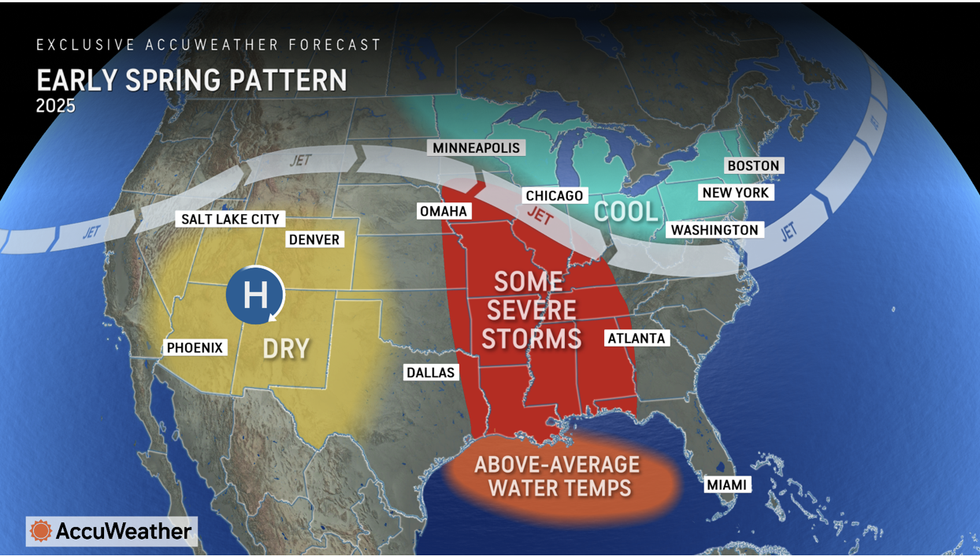
An image of Accuweather’s early spring pattern
ACCUWEATHER
AccuWeather meteorologist Paul Pastelok said: “Families and businesses across the Mississippi and Tennessee valleys need to prepare for a stormy spring.
“This forecast is concerning compared to Tornado Alley, more people live in harms way in the Mississippi and Tennessee valleys, and more of those families are in vulnerable buildings without basements like mobile homes.
“Cold air from Canada clashing with warm, moist air from the Gulf provides the fuel and energy for life-threatening thunderstorms.”
The thunderstorm risk will crank up through the middle of spring, he said, as further regions fall into the firing line.
Damaging storms similar to Atlantic hurricanes, known as derechos, will add to the chaotic forecast, he added.
LATEST DEVELOPMENTS:
- Met Office issues yellow ice warning as plummeting temperatures heighten ‘accident and injury’ fears
- UK weather: Frost and ice RETURN with temperatures ‘plummeting’ as bitter conditions strike Britain
- UK weather: 10 day freeze hits Britain as Arctic winds put nation in path of collapsing Polar Vortex
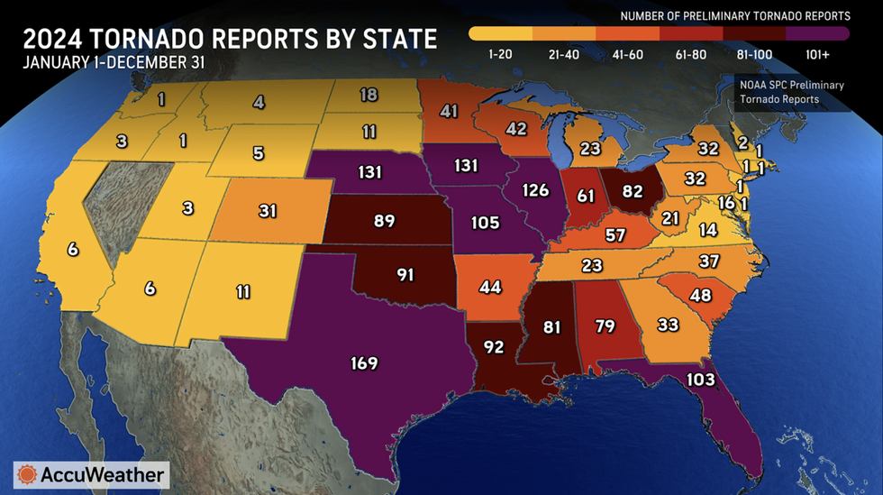
Accuweather’s tornado report by state in 2024
ACCUWEATHER
He said: “The risk of severe thunderstorms is expected to increase in April and become more widespread by May when a shift in the overall weather pattern will open the door for more storms across the Midwest, mid-Atlantic and across parts of the traditional Tornado Alley.
“The risk of long-lived, destructive storms, known as derechos, will also be on the rise late in the spring and into the summer.
“Derechos are also known as ‘inland hurricanes’ because of their intense winds, long tracks, and widespread damage.”
America’s incendiary weather through winter has been fuelled by battling tropical and Arctic airmasses.
More cold weather forecast to the north through the coming days as southerly temperatures rise could signal an imminent tornado risk.
Jim Dale, US meteorologist for British Weather Services and co-author of ‘Surviving Extreme Weather’, said: “This clash of air masses will decide whether we do see an increase in tornado incidence through the season.
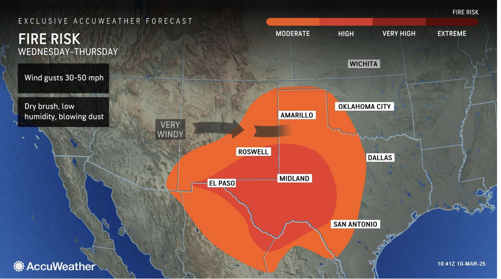
Accuweather’s fire risk spreads across Texas, Oklahoma and New Mexico
ACCUWEATHER
“To the south, across Texas, temperatures are already rising well above average for this early in the season, and to the north, the Polar Vortex is likely to remain over the country driving colder conditions.
“Once the cold air comes further down, and meets the warmer air, that is where we are going to see the greatest risk of storms.”
In the short-term, tropical winds to the south of the country through the rest of the week threaten wildfires.
Temperatures rocketing to 90F across some desert states will fuel the risk from 70mph bone-dry gusts.
AccuWeather senior meteorologist Tom Kines said: “The risk of wildfires and dust storms is expected to ramp up across the Southwest as the storm pushes eastward, bringing powerful winds to areas with exceptionally dry conditions.
“The risk will intensify on Friday with wind gusts of 40-70 mph expected across the region.
“This is a dangerous combination of gusty winds in areas with low humidity levels and dry brush.”
The US National Weather Service (NOAA) has issued warnings across Texas and New Mexico facing a ‘critical’ fire risk.
A spokesman said: “The combination of winds and entrenched dry air will support a Critical Fire Weather risk through the rest of the week.”