A rapidly deepening Atlantic disturbance has sparked warnings to brace for “a serious hurricane threat on the doorstep”.
A potential mega storm, feared powerful enough to become Hurricane Helene, has erupted in tropical waters off the US coast.
Meteorologists have urged people to “prepare now” with rapid growth of the system expected through the coming days.
AccuWeather chief meteorologist Joh Porter said: “We want people to be prepared, not scared, they should be ready and be flexible.
 The Gulf of Mexico is being watched for thunderstorm activity close to an explosive region of low pressureThe Weather Channel
“We could be dealing with a serious hurricane threat on our doorstep by the middle of the week.
“We are concerned that a tropical storm can form in the Caribbean or Gulf and approach the United States, and there won’t be many days to track it.
“It could impact offshore oil and gas operations in the Gulf of Mexico, as well as petroleum industries, refineries, fishing, cruises, and the tourism industry.”
Helene would be the eight significant storm to build in the Atlantic during the start of an anticipated busy season.
Warm ocean temperatures and the steer of the jet stream over the coming weeks will combine the ingredients for tropical mayhem.
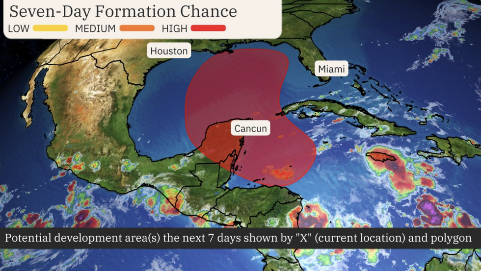
The Gulf of Mexico is being watched for thunderstorm activity close to an explosive region of low pressure.
Depending on where development occurs around the so-called Central American Gyre, a major hurricane could spawn.
LATEST DEVELOPMENTS:
Alarm bells sounded last week when a cluster of thunderstorms were spotted brewing in the western Caribbean
The Weather Channel
Weather Channel meteorologist Jonathan Belles said: “A broad area of low pressure called the Central American Gyre is expected to form over Central America early in the week, giving rise to increasingly stormy weather.
“The middle to end of the week is when the window opens for the formation of a tropical depression or storm in the northwest Caribbean or southern Gulf from this broad area of low pressure.
“The next storm name is Helene.”
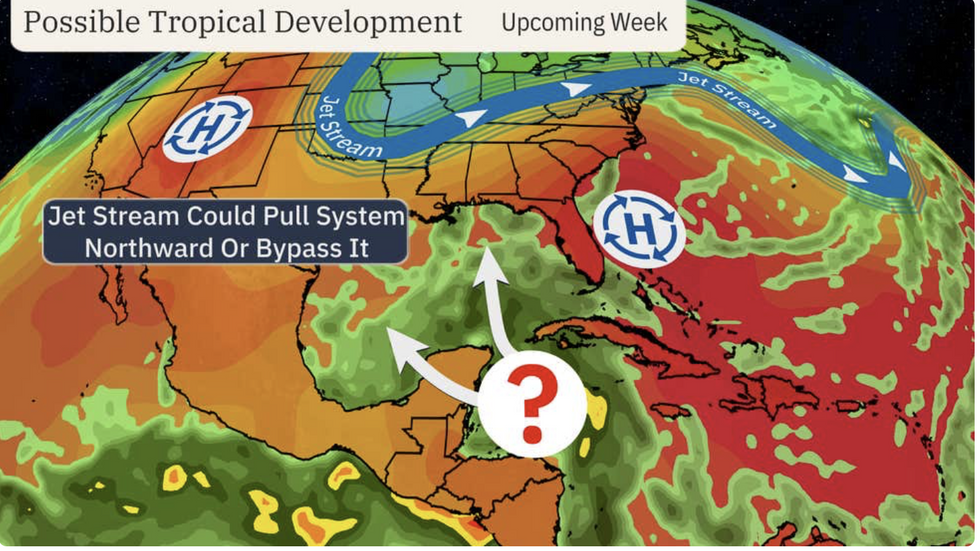
AccuWeather meteorologist Alex DaSilva said: “The more we look at this forecast and the latest guidance, the more concerned I am about a potential hurricane developing in the Gulf of Mexico.
“If there is a stronger dip in the jet stream, it is more likely to pull the storm north and east toward Florida.
“If the trough is a bit weaker, the developing storm could meander further northwest in the Gulf and potentially threaten the central Gulf coast.”
Alarm bells sounded last week when a cluster of thunderstorms were spotted brewing in the western Caribbean.
‘Bath-tub’ sea temperatures in the region have will drive rapid development of the storm, according to DaSilva.
He said: “Much of the Gulf of Mexico and the Caribbean have some of the hottest water temperatures ever on record right now.
“That bathtub-like water can help developing storms explode in intensity.”
Jim Dale, US weather correspondent for British Weather Services and co-author of ‘Surviving Extreme Weather’, said: “It is the Gulf of Mexico and the Caribbean that will need watching this week for the development of this storm, which could become significant.
“It is going to bring a lot or rain, particularly to southern coastal regions, boosted by energy provided by unusually high sea temperatures.”