An “Arctic anticyclone” slumping over the United States will spawn a frenzy of snow-laden winter storms.
More than 200 million Americans are warned of plummeting temperatures, freezing rain, hail, ice and eruptions of “thundersnow”.
A huge region of high pressure, also called an “anticyclone”, will move across upper states from the North Pole.
The National Weather Service (NOAA) has issued warnings for “extreme cold weather”, winter storms, gales, floods and “inch-per-hour” snowfall.
More than 200 million Americans are warned of plummeting temperatures, freezing rain, hail, ice
ACCUWEATHER
A spokesman said: “An Arctic high over the Northern Plains will by Thursday slowly move southward to the Central and southern Plains.”
“Cold air will bring temperatures 25F to 35F degrees below average across the Northern Rockies eastward to the Upper Great Lakes and southward to the Central High Plains.”
“This has prompted an Extreme Cold Warning over the Northern Rockies to the Northern Plains.”
Freezing air from the Arctic will crash into warm air from the tropics sparking a “frenzy of storms”.
MORE LIKE THIS:
- US weather: Americans brace for ‘relentless storm frenzy’ as Arctic air mass collides with tropical blast
- US weather: America set to be battered by violent thunderstorms, tornadoes and ‘snow squalls’ as tropical plume will collide with frozen temperatures
- US weather: ‘Coast to coast’ snow blizzard threatens to bring ‘worst winter storm in 100 years’
Driven by the jet stream as it surges across America, a barrage of low-pressure “cyclones” will unleash torrents of snow amid eruptions of thunder – so-called “thundersnow”.
Volatile weather conditions could also spark tornadoes with heavy rain putting swaths of the country on flood alert.
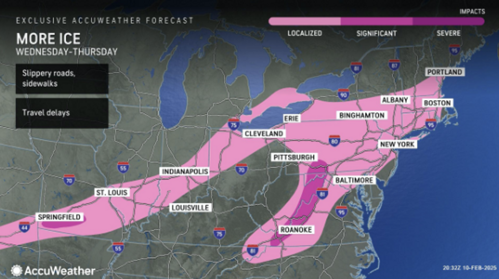
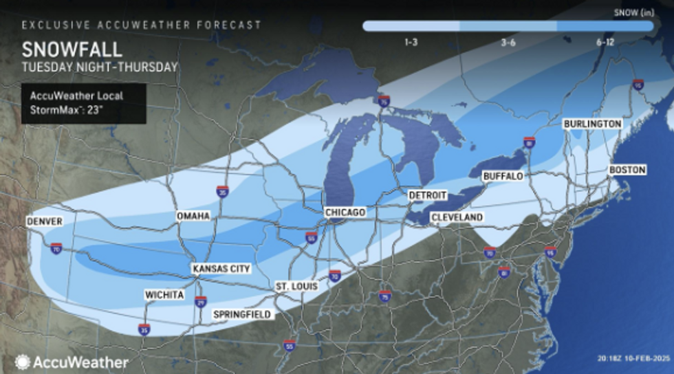
The NOAA spokesman said: “A significant winter storm begins on Tuesday, and this will produce heavy snow from northeast Kentucky into West Virginia.”
“Snowfall rates will sometimes reach one inch per hour, with heavy, wet snow totals of four to eight inches expected.”
Freezing air from the Arctic will crash into warm air from the tropics sparking a ‘frenzy of storms’
ACCUWEATHER
“Isolated power outages are possible, and travel may become extremely hazardous.”
“Hazards associated with thunderstorms are frequent lightning, severe thunderstorm wind gusts, a few tornadoes, and a minimal threat of hail.”
Across Gulf states, violent storms fuelled by tropical airflow threaten flooding and mudslides.
Heavy rain falling across regions hit by recent wildfires will run in torrents of “burn-scarred” ground.
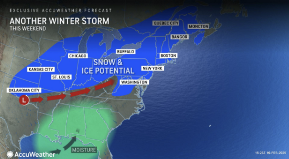
AccuWeather senior director of forecasting operations Dan DePodwin said: “The February frenzy of storms will continue through the weekend with relentless rounds of snow and ice in parts of the Midwest, mid-Atlantic, and the Northeast.”
“More than 148 million people could be impacted by snow, sleet, freezing rain, or ice this week as two storms push through the Midwest to the Northeast and mid-Atlantic.”
“We have a third winter storm on the horizon late this week and this weekend, and possibly a fourth winter storm early next week.”
AccuWeather’s chief meteorologist Jonathan Porter added: “Deep tropical moisture will be funnelled right into Southern California.”
“Deep tropical moisture will be funnelled right into Southern California”
ACCUWEATHER
“Heavy rain falling too fast and furious could cause dangerous impacts in and around areas that were destroyed by recent wildfires.”
The ferocious army of storms is being driven by stark temperature contrasts across the US.
Freezing air spilling in from the Arctic will crash into unusually warm tropical air to the south setting off a powder keg.
Jim Dale, US meteorologist for British Weather Services and co-author of Surviving Extreme Weather, said: “The really intense cold in the north is coming into contact with milder, more moist air to the south and this is where we are going to see storms.
“These will get more intense as warmer air pushes north, and with the tornado season at its peak in spring, there will be the risk of tornadoes.”