Ferocious cold gripping more than 20 states as record heat bakes the rest of the country will leave America split down the middle into spring.
Jet-stream winds swerving thousands of miles across the US through February will continue to funnel Arctic air into the north as Gulf States hit 80F.
Freakish weather swings will test temperature records in the south this week as a deadly ice storm grips northern and eastern regions.
The US National Weather Service (NOAA) has winter storm and winter weather alerts in force this week across 20 states.
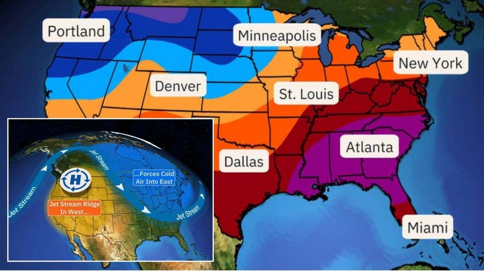
Ferocious cold gripping more than 20 states as record heat bakes the rest of the country will leave America split down the middle into spring
The Weather Company/ Atmospheric G2
Meanwhile as thermometers rocket, ‘Red Flag’ wildfire warnings have been issued across Colorado, New Mexico, Texas and Oklahoma.
A NOAA spokesman said: “A winter storm will impact the Midwest and Great Lakes region through the Ohio Valley, Mid-Atlantic and Northeast with a combination of snow, sleet and freezing rain.
“Over the southern US, and to the south of a strong frontal zone, very warm
temperatures will span the Four Corners region eastward across the southern Plains and most of the Gulf Coast states.
“High temperatures will locally reach well into the 80Fs, and record-high temperatures will be as much as 20F to 30F-plus degrees above normal.”
LATEST DEVELOPMENTS:
Jet-stream winds swerving thousands of miles across the US through February will continue to funnel Arctic air into the north as Gulf States hit 80F
The Weather Company/ Atmospheric G2
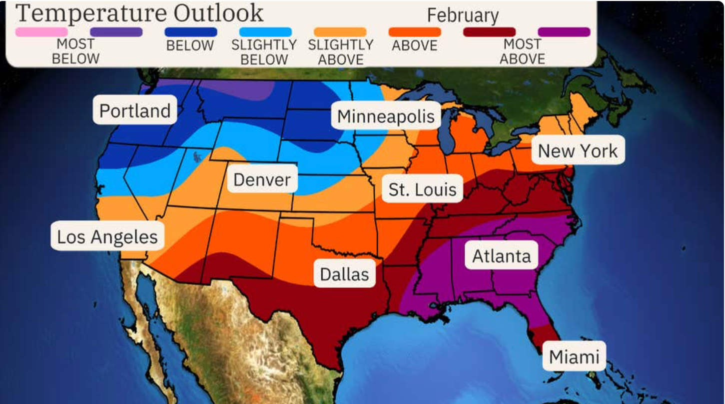
February shows little change from the topsy-turvy weather with a cold-hot, north-south split forecast through the month.
Northern Plains and north-western states will stay in the firing line of Arctic snow as the heatwave risk grows to the south.
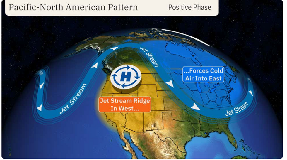
Straddling the nation is the southwards-swerving jet stream, funnelling cold air from the north, according to The Weather Company and Atmospheric G2.
A Weather Company spokesman said: “Patterns of the jet stream, including sharp southward plunges and domes of high pressure, help steer storm systems that either deliver or deflect cold air.
“February should start out generally colder from the Northwest to the Northern Plains, and occasionally into the Great Lakes and Northeast as some cold air in western Canada sweeps across the northern tier. Meanwhile, the southern tier of the country should be warmer than usual for this time of year.
‘Red Flag’ wildfire warnings have been issued across Colorado, New Mexico, Texas and Oklahoma
The Weather Company/ Atmospheric G2
“For the month as a whole, most of the East and South are expected to be warmer than average, particularly from the mid-Atlantic and Southeast to coastal and southern Texas, but a colder February is expected in the Northwest, Northern Rockies and Northern Plains.”
Northern states continue to battle a savage Arctic ice storm threatening heavy snow and dangerous travel into the weekend.
Up to six inches of snow could hit North Dakota into the Upper Peninsula of Michigan, according to AccuWeather.
Meteorologist Jonathan Porter said: “Significant ice storm impacts are expected across a portion of the central Appalachians, through northern Pennsylvania and southern New York, and accumulations of up to half an inch of ice are possible in some spots.
“Half an inch of ice accumulation can add 500 pounds of weight or more to power lines, and tree branches coated in ice can snap and fall on power lines.
“Families and businesses should be prepared for the risk of extended power outages that could leave them without heat and utilities for several days after the storm.”