The Met Office has issued a major update on its weather warnings as Storm Ashley descends on the UK today.
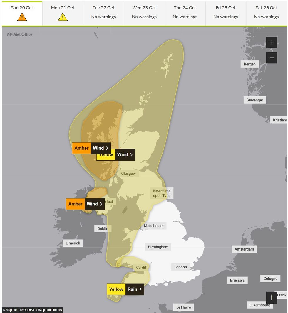
The entirety of Scotland and Northern Ireland are under a yellow warning for wind, with an amber warning in effect for northwest Scotland from 9am on Sudnay until midnight.
However, the national weather forecaster has since issued an update at 10am on Sunday to expand the amber warning area of effect.
In a fresh warning to UK residents, the Met Office expanded the alert to now cover most of Northern Ireland including County Antrim, County Fermanagh, County Londonderry, and County Tyrone.
⚠️⚠️ Amber weather warning issued ⚠️⚠️
Wind across parts of Northern Ireland
Sunday 1300 – 2000Latest info 👉 https://t.co/QwDLMfRBfs
Stay #WeatherAware ⚠️ pic.twitter.com/PaYlJ0tTcc— Met Office (@metoffice) October 20, 2024
The fresh alert warns: “Storm Ashley will bring a period of southwesterly gales during Sunday afternoon and early evening across much of western and northern Northern Ireland.
“Gusts are expected to reach 60 to 70mph for a time before easing from the west. Some disruption to transport and power supplies is likely.”
Although the warning in Scotland makes clear there is a “danger to life” the Met Office alert in Northern Ireland does not go as far.
However, it does say that “being outside in high winds makes you more vulnerable to injury.”
Met Office meteorologist Dan Stroud warned that “very strong, severe gales” coinciding with high spring tides could result in “very large waves”.
LATEST DEVELOPMENTS:
Met Office issues fresh update on Storm Ashley amber alert
Met Office
The powerful storm formed as a low pressure system moved into a jet stream, undergoing rapid deepening in a process known as explosive cyclogenesis or a ‘weather bomb’.
In a blog post about the storm, Netweather forecaster Nick Finnis explained: “A fairly innocuous looking area of low pressure over the mid-North Atlantic this morning, to the north of the Azores, will undergo rapid deepening later today, as the low moves on to the polar side of a powerful 200 mph+ jet stream and into the developmental left exit region of the jet streak.
“This exit area of the jet stream is where very strong winds aloft fan out and cause divergence of the air aloft, creating a void which has to be filled by air rising up from below.
“This in turn causes air convergence at the surface and so lowers pressure at the surface, helping areas of low pressure deepen explosively.”
Meteorologists observed the storm’s central pressure drop by 44 hPa in less than 24 hours, far exceeding the criteria for a ‘weather bomb’.
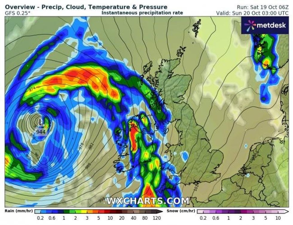 Storm Ashley: WXCharts map shows intense low pressure to west of UK WXCharts
Where and when are the Met Office weather alerts in force?
Amber wind alerts are in force in Scotland and Northern Ireland
In Scotland:
Highlands & Eilean Siar and Strathclyde between 9am and midnight on Sunday
In Northern Ireland:
County Antrim, County Fermanagh, County Londonderry and County Tyrone between 1pm and 8pm on Sunday
Yellow wind alerts are in force across the rest of Scotland, northern England and Wales:
In Scotland:
Central, Tayside & Fife, Grampian, Highlands & Eilean Siar, Orkney & Shetland, SW Scotland, Lothian Borders, Strathclyde between 3am and midnight on Sunday
In England:
North east and north west England including Merseyside, Cumbria, Lancashire, Durham, Newcastle and Northumberland between 3am and midnight on Sunday
In Wales:
Ceredigion, Conwy, Denbighshire, Gwynedd, Isle of Anglesey and Pembrokeshire between 3am and midnight on Sunday
Met Office deputy chief meteorologist Tony Wisson said: “Storm Ashley will bring strong winds for most of the UK on Sunday before it clears on Monday, with a chance of some disruption across parts of Scotland, Northern Ireland, Northwest England and West Wales.
“A period of especially strong winds is expected on Sunday afternoon and evening in western Scotland, where gusts could potentially reach 70 to 80mph in exposed areas and an amber warning for winds has been issued here.
“More generally 50 to 60mph are possible in some inland areas in other parts of the warning area, especially Northern Ireland and western Scotland, and perhaps up to 60 to 70mph along exposed coasts and hills. These strong winds in conjunction with high spring tides, may cause some disruption.
“It is important that people stay up to date with the latest forecast and our warnings.”