America is on alert for another ‘major’ superstorm as Hurricane Kirk gathers pace to join the assault.
Just days after Hurricane Helene left a 100-billion-dollar dent across eastern states, the eleventh storm of the season is flexing its muscles in the Atlantic.
Warm tropical waters that fed Helene up to a Category-4 monster will fuel Kirk as it hurtles along a similar collision course.
Weather Channel meteorologist Robb Ellis said: “The tropics remain very active with a new tropical storm that we are tracking.
“Kirk is going to continue tracking to the west and is likely to become potentially even a major hurricane over the next several days.
“The next two names on the 2024 list are Lesley and Milton.”
 Hurricane Kirk is set to cause chaos for AmericaTHE WEATHER CHANNEL
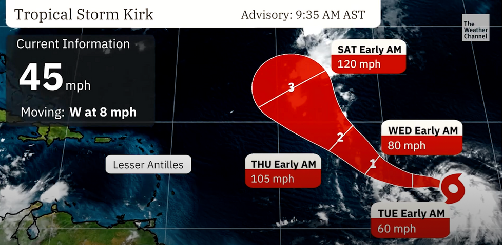
Kirk was last night churning north-westwards towards the east coast of America with wind speeds of 75mph.
It is expected to strengthen through the coming days thanks to warmer than average Atlantic Ocean temperatures.
The storm may veer north-eastwards this weekend, dodging a full impact with land, according to the US National Hurricane Centre.
A spokesman said: “Kirk is expected to continue strengthening in the coming days.
“Global models forecast the deep-layer vertical wind shear to remain weak and warm sea surface temperatures along the forecast track during the next few days.
“Kirk is a large system and expected to grow larger as it moves northward, with tropical-storm-force winds extending far from the centre.”
Kirk was last night churning north-westwards towards the east coast of America with wind speeds of 75mph
ACCUWEATHER
It is expected to strengthen through the coming days thanks to warmer than average Atlantic Ocean temperatures
ACCUWEATHER
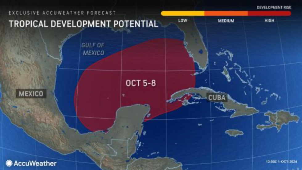
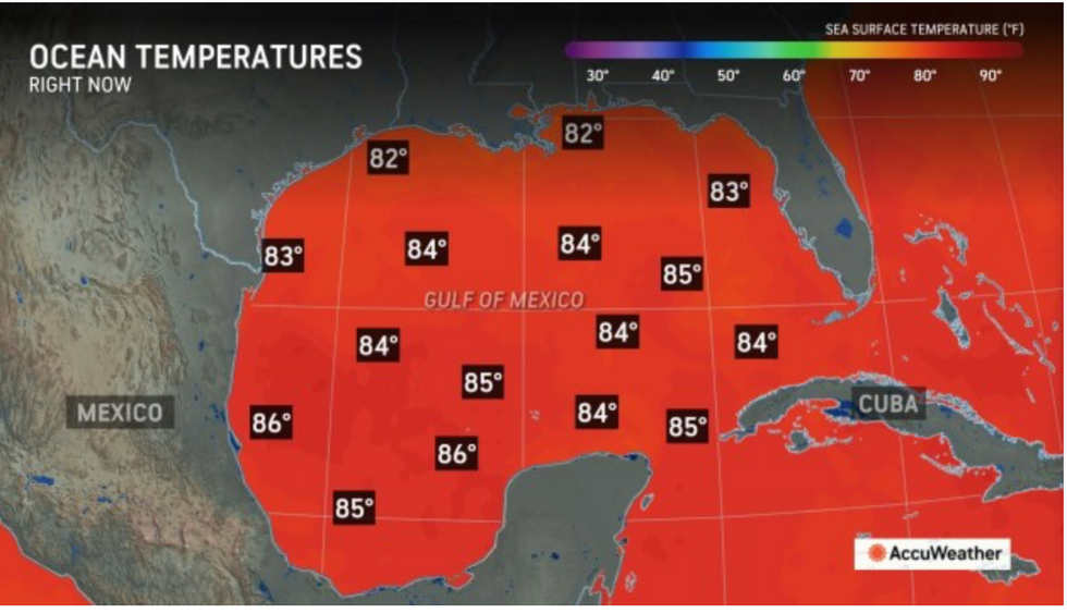
Another storm brewing closer to the Gulf of Mexico has meteorologists’ fingers hovering over the panic button.
Sea water temperatures above 80F in the region will feed the next ‘home-grown’ assault.
AccuWeather meteorologist Bernie Rayno said: “There are two features–two scenarios we are looking at this week.
“This really looks like a threat of heavy rain and possibly a wind and surge threat, depending on storm strength.”
AccuWeather meteorologist Alex DaSilva added said: “Water temperatures continue to remain warm in the wake of Helene over the south-eastern Gulf of Mexico.
“There is little to inhibit Kirk, and a high-end hurricane that is mostly a threat to central Atlantic shipping is forecast for mid- to late week.
“Because few obstacles are in its way, Kirk has the potential to last a long time.”
Meteorologists fear an unusually active tropical hurricane season, driven by ocean temperatures and a transition of El Nino – warming of the eastern Pacific – to it’s cooler counterpart, La Nina.
After an unusually quiet start to the season, the past few weeks have brought 10 named storms, the latest being Helene.
Jim Dale, US meteorologist for British Weather Services and co-author of ‘Surviving Extreme Weather’, said: “We are probably going to be seeing more of these in the coming weeks, and they could be greater in intensity and unusual in the speed at which they develop and intensify.
“This is a symptom of the changing climate and shows the effect of warmer temperatures on the volatile nature of the weather.”
Once again, Florida and the southeast Gulf coast are at greatest risk this week from storm threats.
The greatest impact will be from heavy rain falling on communities already flooded from Helene.
Weather Channel meteorologist Chris Dolce said: “Tropical development is possible from the north-western Caribbean Sea into the Gulf of Mexico later this week into next week.
“Increased rainfall in Florida and along other parts of the Gulf Coast is one impact we will see by this weekend into next week.
“The western Caribbean and Gulf are typical areas for tropical development in October.”